Zones archives

New animation illustrates that at huge distances such as 1,500 feet, sentencing enhancement zones can't work.

by Bernadette Rabuy, June 18, 2015

One of the worst ideas to come out of the War on Drugs is sentencing enhancement zones. These laws mandate a higher penalty for crimes committed within a certain distance of schools. The intent is noble, but at huge distances like 1,500 feet, the laws are actually harmful.

Alternative Spring Break participant Arielle Sharma, research associate Elydah Joyce, and programmer Jacob Mitchell put together the illustration below to show just how far 1,500 feet really is. Just click on the image to understand why school zones fail to keep children safe. And check out our zones page for updates on the pending Connecticut bill that would roll back these zones, our reports on zones in Connecticut and Massachusetts, and our zones video.

To embed this animation on your own website, use this code:


Our new video explains that sentencing enhancement zone laws (a.k.a. school zone laws) do not work and will never work.

by Peter Wagner, June 30, 2014

One of our specialties here at the Prison Policy Initiative is explaining the geographic implications of criminal justice policy. Sometimes we focus on how criminal justice policy — and the forced migration of millions of people to remote prisons cells — distorts our electoral process through prison gerrymandering.

We’ve also been working from the other end, focusing on the geographically-flawed thinking in state legislatures that punishes some drug crimes more severely because they happen to be committed in an urban area. These laws don’t work, can’t ever work, and lead directly to increasing the racial disparities in our nation’s prisons.

Over the years, we’ve done a number of detailed state specific reports about the problem and the obvious solutions, and today we present a short video that explains the fundamental flaw in these laws: When you make everywhere special, nowhere is special.

For more information, see our overview page about sentencing enhancement zones, and some of our previous reports:

  • report coverReaching too far: How Connecticut’s large sentencing enhancement zones miss the mark

    by Aleks Kajstura, March 2014.
    This report analyzes Connecticut’s 1,500-foot sentencing enhancement zones, mapping the zones in the state’s cities and towns and demonstrating both that the law is ineffective, and that it creates an “urban penalty”.

  • cover of the reportThe Geography of Punishment: How Huge Sentencing Enhancement Zones Harm Communities, Fail to Protect Children

    by Aleks Kajstura, Peter Wagner and William Goldberg, July 2008.
    This first-of-a-kind report mapped every sentencing enhancement zone in urban, rural and suburban Hampden County, and quantified the race and ethnicity of the people who live inside and outside of the zones.

  • thumbnail of graphic in report Reaching too far, coming up short: How large sentencing enhancement zones miss the mark

    by Aleks Kajstura, Peter Wagner and Leah Sakala
    January, 2009.
    This followup report again focusing on Hampden County Massachusetts found that Blacks are 26 times as likely, and Latinos 30 times as likely as White residents to be convicted and receive a mandatory sentencing enhancement zone sentence.


Conn. legislators continue to support over-reaching, diluted, version of sentencing enhancement law creating urban penalty, failing to protect children.

by Aleks Kajstura, April 4, 2014

As I watched the Connecticut Judiciary Committee’s discussion of sentence enhancement zone reform (SB 259) before its successful vote on Wednesday (SB 259 begins at 02:09:35), I was struck by how many Connecticut legislators continue to support an over-reaching, diluted, version of the state’s sentencing enhancement law. It’s frustrating to see that legislators who have had years to study this issue still misunderstand both, the law’s function and the bill to strengthen it.

Senator Kissell explained the long-held support for the law in his region of the state (at 02:12:15):

Former Rep. Bill Kiner, who was in the House of Representatives over 20 years ago, helped champion the underlying law. And, at least in my neck of the woods… when I said, “Well, should the whole state have that enhanced penalty?” They said, “Sure!” …. [R]educing the distance to the schools goes in the wrong direction… They [constituents] don’t want us to weaken the underlying laws.

It may be counter-intuitive, but by shrinking the zones, the bill would actually strengthen the law. The law relies on the protected spaces to have harsher sentences than other areas. But the 1,500-foot distance, creates no such protected spaces, because nearly entire cities are covered – leaving no specially protected area around schools. The effect is in essence no different than what Sen. Kissell’s constituents say they want, everywhere having an “enhanced penalty”. But when everywhere has an enhanced penalty, then that’s just the penalty, there is nothing “enhanced” about it. If the legislature would like to reconsider the penalties for drug offenses that’s a separate question, but the mechanism of this law, meant to protect children from drug activity, relies on additional – enhanced – penalties around specific protected places.

Sen. Kissell concluded (at 12:18:02) that: “there’s not an easy answer to this… because on the one hand, I think that we want to be fair and even handed but on the other hand we don’t want to say that ‘we are ok with people selling drugs’ and ‘let’s cut back the barriers’…. I’m not so sure that enhancing penalties but reducing the distance gets us to where we wanna go”

I disagree, the bill actually does present a simple answer without giving the message that the legislature would be “ok with people selling drugs”. This bill would not legalize any drug offense. The sentences for the underlying offense would remain unchanged, and the bill would in fact concentrate the state’s enforcement resources around schools to actually protect kids from drug activity. As Representative Meyer explained (at 02:28:40):

When you charge a person, an adult selling drugs to another adult, more than a quarter mile from the school and when the law, as this law does, imposes a mandatory a one year extra imprisonment… it doesn’t relate any longer to creating a school safety zone….

…in concept it’s very important to create a school safety zone, but once you make it 1,500 feet and you’re having one adult selling to another and it doesn’t involve school safety in any respect… [T]he Sentencing Commission is bringing us some reality here and actually is making the school safety penalty stronger by its proposal and now by this bill.

Sen. Kissell points to arrests as proof that the law works (at 02:15:57). But in fact, these arrests prove the law doesn’t work, in several ways. First, the law is meant to move drug offenses out of these zones, so if the law worked, we would see few arrests in the zones (and possibly more outside the zones as the law’s deterrent effect takes hold). Arrests inside the zones prove that the law is not working to move those activities elsewhere. Second, to have a better sense of the law’s imact we need to look at the type of arrests made, not just their number. Sen. Kissell stated (at 02:16:47) that “If the argument is that … people are being put behind bars, then it [the law] is having some kind of impact.” Sure, the law has an impact, but the question is: does it have the desired impact?

The goal of the law is to keep drug activity away from children, but as Rep. Meyer hinted at, nearly all of the arrests do not involve students – and those that do, involve only students (in one case a few students sitting outside the school smoking marijuana). Reducing the zones to the 200 feet proposed by the bill would allow the law to have a meaningful impact by setting aside specific uniquely protected spaces. Connecticut would still maintain serious penalties for drug offenses, and the extra mandatory minimum penalty would be reserved for those offenses committed near a school.

For more information about the law and proposed solutions, check out our sentencing enhancement issue page, and my recent report.


Published a new report on Conn.'s sentencing enhancement zones, presented findings at legislative breakfast.

by Aleks Kajstura, March 28, 2014

report coverThis morning I presented our new research on Connecticut’s sentencing enhancement zones at an informational Legislative Breakfast hosted by A Better Way Foundation, Unitarian Universalist Society: East Manchester, and Senator Gary Holder-Winfield.

Connecticut Representative Brandon McGee and PPI Legal Director Aleks Kajstura discuss Hartford's sentencing enhancement zones

I discuss Hartford’s zones with Representative Brandon McGee

The report, released today, analyzes Connecticut’s 1,500-foot sentencing enhancement zones, mapping the zones in the state’s cities and towns and demonstrates that the law doesn’t work, it cannot possibly work as written, and that it creates an unfair two-tiered system of justice based on a haphazard distinction between urban and rural areas of the state.

Connecticut’s 1,500-foot sentencing enhancement zones, meant to protect children from drug activity, are some of the largest in the country. I described how the law’s sheer expanse means it fails to actually set apart protected areas and that it arbitrarily increases penalties for urban residents.

Connecticut Senator Gary Holder-Winfield speaks at the breakfast

Senator Gary Holder-Winfield speaking at the breakfast

SB 259, currently pending before the Judiciary Committee, would decrease that size to a more effective 200 feet. This would allow the law to actually create the specially protected places it was intended to in the first place. Making the zone smaller would come much closer to the law’s original intent, and largely get rid of the urban penalty effect. For more details on the bill, check out my written testimony (with maps).


We produced a map to illustrate the ACLU’s testimony against a counterproductive zone law.

by Peter Wagner, October 17, 2013

The Michigan ACLU testified yesterday against a bill proposing counterproductive and ineffective restrictions on where people on the sex offender registry would be allowed to “loiter”. This bill would expand the current restrictions to also include all areas within 1,000 feet of a day care center, creating “a nearly impossible burden on listed offenders and on law enforcement.” Here at the Prison Policy Initiative, we produced a map to illustrate the ACLU’s testimony by demonstrating that the simple-sounding law would blanket dense urban areas with a confusing pattern of imperceptible zones.

map showing how a law drawing 1000ft no-loitering zones around 10,000 day care centers would blanket the city of Lansing Michigan

Our map showing that most of the Michigan capital city of Lansing is within 1,000 feet of just two dozen of the 10,729 day care centers in the state.

Litigator Kung Li stopped by our office in August to talk about her experience working with us on the Southern Center for Human Rights’ Whitaker v. Perdue case.

We’ve also prepared similar analysis for court cases in Colorado, Georgia, Massachusetts and elsewhere. This work grew out of our research on sentencing enhancement zones, the drug laws that give enhanced penalties based on where an offense occurs, not on its dangerousness. These laws are all too common, and the basic differences are the number of protected places, the distances involved, and how that distance is to be measured.

In all the cases we’ve looked at, a few key points about geography and geometry keep coming back:

  • Drawing large circles around thousands of places blankets entire cities in “protected” or “off-limits” areas.
  • Doubling the distance in one of these statutes makes the protected area four times as large (remember pi r squared?).
  • 1,000 feet — and most distances, for that matter — are actually much further than most people assume.
  • Laws that measure the distance as the crow flies extend coverage to areas that are, for all practical purposes, very far away.
  • Laws that measure the distance on a property line-to-property line basis cover considerably more area than simple 1,000 foot circles drawn around the center point of a particular property.

Most importantly, however, the laws that fail to work as intended share the same fundamental flaw of covering too much area. This might sound like it would produce more safety but it actually produces less for the simple reason that when you make everywhere special, nowhere is special.


Leah reports back from a hearing on the zone law before the Massachusetts Supreme Judicial Court.

by Leah Sakala, October 8, 2013

The Massachusetts Legislature took a step in the right direction last year when it reformed the state’s sentencing enhancement zone law. But now the highest court in Massachusetts must decide just when the new law began to take effect.

Basically, lots of states have sentencing enhancement zone laws that aim to keep illegal drug activity away from kids by saying that if you commit drug offenses within a certain distance of a place like a school, you get a mandatory extra sentence for your crime. But until last August, the Massachusetts law created enormous 1,000-foot zones that blanketed entire urban areas. Our two reports found that huge zones end up defeating the whole purpose of the law because when you make everywhere special, nowhere is special. Furthermore, the law increases racial disparities in the justice system because dense, urban communities that are disproportionately made up of people of color are most impacted by zone laws.

Last August, the Massachusetts legislature realized that the 1,000-foot zones weren’t doing the job, and were actually causing harm. So lawmakers took our advice to reduce the size of the zones, reining them in to a more reasonable 300 feet.

Yesterday I attended a hearing in Boston before the Massachusetts Supreme Judicial Court to consider which version of the law should apply to people who were arrested before last year’s law change, but sentenced afterwards. Since this case is largely revolves around a procedural question, much of the hearing was spent talking about the technicalities of the legislation.

For me, the most memorable moment was when the District Attorney raised a concern that applying the law retroactively could create a disparity between people who had their court dates before the law was changed, and everyone else. Without skipping a beat, Justice Gants responded by pointing out that the legislature changed the law precisely because the old policy created disparities by giving prosecutors incredible power to bring an extra sentencing charge against people who primarily come from urban communities of color.

At the end of the day, as FAMM’s Barbara Dougan argued in her Amicus Brief, it’s clear that last year’s reform to shrink the size of the zones was intended to immediately improve a major flaw in the 1,000-foot law. Sentencing people to extra prison time based on a law that the legislature has since rejected is clearly not a good policy.

We’ll be following the outcome of this case closely, so stay tuned for updates and a ruling. Also, keep your eyes peeled for our newest video on sentencing enhancement zones. We’re hoping to wrap it up this week!

Leah working on new PPI video


While the harmful older zone law has been scaled back, questions still remain in the courts.

by Leah Sakala, September 24, 2013

Massachusetts has just passed the one-year anniversary of scaling back harmful and ineffective 1,000-foot “sentencing enhancement zones.” As our research found, the old zones were too big to meet the indended goal of deterring drug activity from particular areas. We also found that the old policy led to alarming racial disparities, so we were certainly glad when the legislature reduced the size of the zones to 300 feet.

But, as our friends at Families Against Mandatory Minumums (FAMM) can tell you, a lingering question remains in the courts: should the old rules or the new rules apply to the people who committed offenses before the law was changed, but who were sentenced after the change?

Advocates at FAMM are urging the court to apply the more reasonable 300-foot zone policy to all cases that were pending when the law was changed. We completely agree, and are thrilled that our two reports were cited throughout FAMM’s friend-of-the-court brief.

The case, Commonwealth v. Pagan, will be argued in the Massachusetts Supreme Judicial Court on Monday, October 7, and the public is welcome to attend. I’ll be there, and I hope to see you there, too!


Letter to the editor of the Boston Herald in response to “Going soft on crime,” published Jan. 28 2011.

by Peter Wagner, February 4, 2011

Letter to the editor published in the Boston Herald on February 4, 2011.

Your editorial on the governor’s sentencing bill (“Going soft on crime,” Jan. 28) notes that when it comes to the school zone law, “in a city like Boston it’s pretty hard not to be within 1,000 feet on a school.” As a researcher who has studied the state’s school zone law, I agree. And that’s the problem.

The 1,000 foot distance is itself a flaw. That distance— greater than the length of three football fields— has created school zones so large that few people know the boundaries. Which means that the zones don’t drive drug activity away from children, as intended.

The governor’s bill would reduce school zones to 100 feet of a school or its property, which is the same size as the drug-free zones drawn around parks and playgrounds. A tightly drawn drug-free zone has a greater deterrent effect. His bill also keeps the mandatory minimum stench for school zone offenses and retains two other vital laws that requite mandatory sentences for selling drugs to minors or using them in drug transactions. The governor’s proposal is not soft on crime. It’s smart.

Peter Wagner,
Executive Director
Prison Policy Initiative
Northampton


Affidavit prepared by Peter Wagner for a Revere, Massachusetts case regarding a city ordinance that would banish a person classified as a level 3 sex offender from the city.

by Peter Wagner, August 14, 2006

This affidavit was prepared for a case in Revere Massachusetts where the city was preparing to enforce a city ordinance that would banish a person classified as a level 3 sex offender from the city. The clerk-magistrate declined to issue a complaint and the prosecution did not proceed.

Affidavit of Peter Wagner

1. I, Peter Wagner, am an attorney and Executive Director of the Prison Policy Initiative a non-profit research organization based in Easthampton, Massachusetts. The Prison Policy Initiative focuses on the intersection of criminal justice policy and other social issues. In my role as Executive Director, I regularly make maps and analyze Census data.

2. In March 2004, I gave an invited presentation of my research at “America’s Scorecard: The Census in an Ever-Changing Nation”, an academic symposium organized by the Census Bureau in Washington D.C., and in June 2005 I gave an invited presentation to a panel of the National Academy of Sciences investigating Census Bureau methodology.

3. I am currently leading a project at the Prison Policy Initiative that involves mapping 1,000 foot zones around urban and rural schools in Hampden County and then analyzing the Census populations of the affected areas.

4. On July 12, 2006, I testified in the United States District Court for the Northern District of Georgia in Whitaker v. Perdue (4:06-cv-00140-CC) in support of plaintiff’s motion for a preliminary injunction barring enforcement of HB1059, Georgia’s Sex Offender Residence law. To prepare for my testimony, I prepared maps of 1,000 foot exclusion zones around schools, day care centers, bus stops, parks and other areas listed in the statute as places that people on the sex offender registry cannot live.

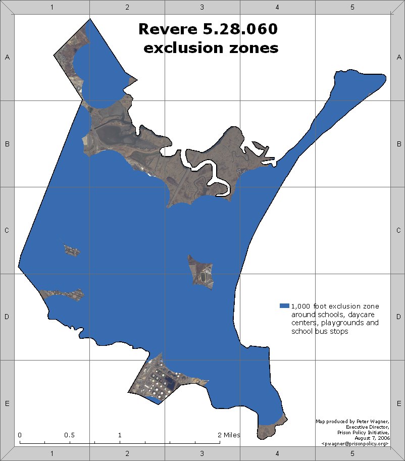
5. I used GIS technology and a software package called Arcview 9.1 to map the areas in the city of Revere which are one thousand linear feet of a public or private school, nursery school, day care center, kindergarten, and playground. The map entitled “Revere 5.28.060 exclusion zones” represents that the Revere ordinance of October 25, 2005 would prohibit level III sex offenders from living in more than 99% of the city. No more than 100 residential buildings in the City of Revere are outside of the ordinance’s exclusion zone.

6. The map “Revere 5.28.060 exclusion zones” shows that the majority of Revere is included in the exclusion zones. The majority of the remainder is industrial (grids E2, E3) Suffolk Downs (C3, D3) or marsh (B2, B3, B4, C3, E4). Most of the land in grid A1 that is not in an exclusion zone is undeveloped woodland.

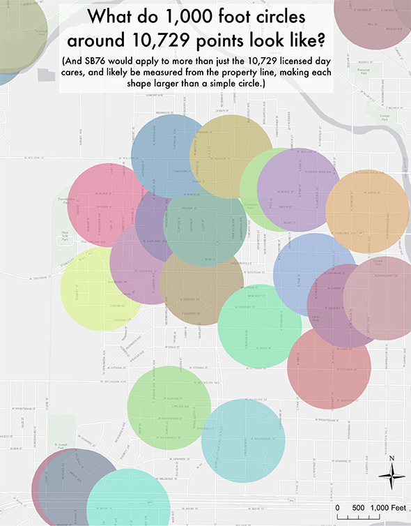
7. Residential houses outside of the exclusion zone can be seen only in Grids A1, C1 and D1. However, many of the houses visible in the photographs may also be off limits to people designated as level 3 offenders for other reasons. First, the map shows the exclusion zones as measured only from a single point on the property of day care centers and schools. In reality, day care centers and schools are much larger than a single point, as they may contain multiple buildings, playing fields, etc, the exclusion zones are actually larger than they appear on the map. Second, while the aerial pictures show structures, they do not show property lines of individual residences. Many of the residential structures seen in the aerial photographs are on properties that partially extend in to the exclusion zone and are therefore off limits to people designated as level 3 offenders. The map “HB1059 exclusion reaches beyond 1,000 feet“, which I prepared for the Whitaker v. Perdue case, demonstrates the drawing simple circles with a radius of 1,000 feet understates the actual impact of the exclusion zones. Finally, aerial photography can only identify structures. It can not, by itself, confirm whether any of the remaining structures outside the exclusion zone are in fact available for rent or purchase.

8. To make these maps I used a variety of data sources:

  • Schools: I used a file created by MassGIS, the Commonwealth’s Office of Geographic and Environmental Information, within the Massachusetts Executive Office of Environmental Affairs that represented each public and private school in the state as of October 18, 2004. This file does not represent the property line of each school, instead showing only one point for each school. The property lines for schools in Revere were not immediately available.
  • Day Care Centers: The Massachusetts Department of Early Education and Care maintains a list of all licensed child care facilities in the state. I used the address of each facility in Revere to place single points on the map. The property lines for day care centers in Revere were not immediately available.
  • Playgrounds: I downloaded the MassGIS database of Protected and Recreational Open Space (last updated February 2006) and filtered it to use only the shapes of properties that had “park” or “beach” in the title.
  • Bus stops: Peter Martino at Revere Transportation Department provided a list of school bus stops which were then placed on the map.
  • Aerial photography: MassGIS publishes aerial photography taken in April 2005 at the 1:5000 scale.
  • The Census block maps and Revere City boundary file was created by the U.S. Census Bureau and distributed by ESRI, the manufacturer of the ArcView GIS program.

9. On August 10, 2006, I learned that the City of Revere had amended ordinance 5.28.060 to restrict people classified as a level 3 from living within 1,000 feet of schools. Based with this information, I made a new map and then overlaid the 1,000 foot exclusion zones over Census Bureau data to determine that at least 4,400 housing units in Revere are now off limits to people classified as level 3 sex offenders. This is 21.8% of the housing units in Revere. Those housing units contain at least 10,252 people, or 21.7% of the city.

10. According to the U.S. Census, in 2000 Revere had 47,283 people and 20,181 housing units. The use of Census Bureau data from 2000 is appropriate for three reasons. First, the decennial census is the only reliable source of block level data. Second, Census Bureau estimates for the entire city show that the population has been relatively stable from 2000 to the most recent estimates in July 2003. The population of Revere in July 2003 was estimated to be 47,002, or only 0.6% smaller. Third, the aerial photography from 2005 shows that there are no new large housing developments outside of the exclusion zones. The unpopulated marsh and industrial areas in Revere remained uninhabitable.

11. As in Paragraph 7, this methodology also understates the impact of the exclusion zones because I used the point of each school’s address rather than its actual border. Schools are significantly larger than a single point, as a school may contain several buildings, playgrounds and other land. Secondly, this methodology also understates the impact of the Revere ordinance because I was unable to show the property lines of individual residences in Revere.

12. Therefore, the fact that at least 4,400 housing units in Revere are off limits to people classified as a level 3 should be seen as only a minimal figure. The actual number of housing units off limits under this ordinance can not be lower than 4,400, but it may be higher.

Signed under the pains and penalties of perjury this 14 day of August, 2006.

Peter Wagner

A map of Revere, MA, with exclusion zones colored in blue. Most of the city is in an exclusion zone.


Stay Informed


Get the latest updates:


Share on 𝕏 Donate